
A list of Issues facing Carlswald Residents in April 2026 (Presented at AGM)
An article by Sean Christie “After Years of Sewage Flooding their Land Joburg Residents Start a Rates Revolt” was published in Ground Up on 17 December 2025. It documents the extent of the sewage and storm-water issues facing Carlswald valley residents.
Eastbourne Road Boomed
Eastbourne Road residents’ persistence paid off when permission was finally granted for booms to be installed In February 2026 (18 months after they started proceedings). The boom at 7th Rd is closed from 6pm to 6am while there is 24 hour access through the boom at the base of Eastbourne (near Norfolk Rd). This is valid for 2 years. Please scroll down for more information including links to newspaper articles.
Storm water
In March 2026, Carlswald (and large areas of Midrand) received over 80mm of rain in one hour. Floods were reported on the N1 and well as many roads with blocked storm-water drains. In Carlswald, 7th Rd, Springfield Rd, Lyncon Rd and the dip on Norfolk Rd were all flooded – all flooded areas correspond with blocked or inadequate storm-water drains.

As development escalated above 7th Rd the volume of storm water increased exponentially. Where rainwater used to sink into the vacant ground which acted like a huge sponge, it now pours down the storm water drains and is channeled along the floor of the Carlswald Valley and exits in the dip on Norfolk Rd where the drainage system is completely inadequate for the volume of water generated.


Storm water has cut dongas several storeys deep along the base of the valley and beneath the old sewage line (parts of which are now suspended over deep gullies).


Bottom: donga approximately 3 storeys deep with collapsed gabion intended to protect sewage line
Sewage Line
The 2025 rains (more between January and April than in the whole of 2024), have escalated the problems faced by residents, notably “The Farm” that comprises 22 hectares and straddles Springfield and Milford roads. See the article in the Midrand Reporter dated 25 April.
The Carlswald sewage line runs down the base of the valley between Milford and Springfield Rds…. and so does the storm water from developments to the east of Milford Rd. The line was designed and built around 25 years ago for Regents Hill, a relatively low-density townhouse development on the south-eastern corner of Milford and Seventh Rds. Despite agreements that it was for the use of Regents Hill and Carlswald residents, all subsequent developments above 7th Rd have connected to it. It is difficult to monitor, access and maintain as it is located in an area without passing traffic. It blocks regularly as residents of these developments flush disposable nappies etc. down their lavatories. This causes the line to become blocked and the manholes to erupt spilling raw sewage down the valley.

Sewage spill from blockage above 7th Rd which ran down the storm-water drains and under 7th Rd resulting in badly polluted dam in Springfield Rd 23 October 2024

Sewage blockage on main Carlswald sewage line which ran into the storm-water channel and into the same dam. JW jetted the line to clear it.
Over the years storm water has dug a deep erosion gully / donga along the base of the valley which is around three-storeys deep, 20 metres wide and runs the length of 3 properties and by 2020 had expanded to the reach the sewage line which ended up being suspended above it. JRA (who are the municipal body whose responsibilities include storm-water management) had been notified about this likelihood on numerous occasions.
In April 2022, the Carlswald Valley sewage line collapsed into the storm water donga / gully on a property in Milford Rd but a team from Joburg Water’s Midrand Depot was able to effect a ‘temporary’ repair within a couple of days.
On Valentines Day 14 February 2023, the Carlswald Valley Sewage line collapsed for the second time into the ever-growing donga for the second time. This year, the amount of rain had caused the bank of the donga to keep collapsing making it too dangerous for Joburg Water to send in their repair teams and they were forced to appoint an outside contractor to undertake the job and it took until 25 February for the line to be replaced.

As the ground above the pipeline was waterlogged, the trucks and TLBs bringing materials to the site became stuck and when the construction team departed John and Madeleine were left a churned-up field which had previously been grassland. Wilf Mole came to the rescue and supplied compost to help re-establish the grass. His workers planted vetiver grass along the edge of the donga. Vetiver has extremely long roots and is extensively used in stabilising eroded areas and cleaning and purifying contaminated water.
The delay in replacing the sewage pipe resulted in millions of litres of raw sewage pouring down the valley and into the dams and wetlands that Wilf Mole has been forced to construct over the last 20 years on his properties at the bottom of the valley. As the flow was so great and over such an extended period in February, Wilf dug a channel from his first containment dam to the first manhole on his property and re-routed the sewage there. He was then able to repair the catchment dams that had breached as a result of the flow of sewage and storm water.

Most properties bordering on the sewage line are oblivious to what is pouring down at the end of their properties: out of sight and definitely out of mind (but not for those who have to deal with it)!
SCENES FROM SEWAGE PIPELINE COLLAPSE AND REPAIR IN APRIL 2022


December 2019 and January 2020 were particularly problematic. Years without maintenance had resulted in the line being severely infested with root growth resulting in blockages when there was a build up of nappies or wet-wipes. Exacerbated by heavy rainfall, the line blocked and hundreds of thousands of litres of raw sewage ran down the valley for several weeks severely polluting our wetlands and dams. This was really challenging in December when storm water entering the sewage system caused a build up of waste among the roots and manholes started erupting all down the line. CRA chairman Wilf Mole has 22 hectares between Milford and Springfield Rd which he bought in the early 60’s. As he is situated where the valley flattens out, he has borne the brunt of all sewage and storm water and over the years has built a series of dams and wetlands to slow the water and contain it. He spent a large part of December building barricades to keep sewage out of his dams and digging trenches to channelling sewage from one manhole to the next when the lines blocked. It was only due to a barrage of correspondence with JW (accompanied by legal representation) that JW finally jetted the entire line in January.


Eastbourne Rd
Taxi on Eastbourne Rd (Midrand Reporter 20 September 2024). https://youtu.be/oYlYXNK6Pr8?si=DxYFKL2oEATWlSIk


Eastbourne Rd is untarred and irregularly graded by JRA. Owing to the volume of traffic and resultant traffic jams at rush hour, (notably on the intersection of 7th Rd and Harry Galaun Dr), it became a favoured ‘rat run’, especially for speeding taxis whose drivers had little regard for road rules or the safety of their passengers or fellow road users. The amount of dust generated (particularly before the rains start) caused residents to liken it to be like ‘being engulfed in a sandstorm’. Crime had also increased markedly with increased awareness of Eastbourne Rd.
Residents, spearheaded by Karen Kruger (with major support from Adi Stephens and Mandla Nhlapo), came together with Ward 112 Councillor Lerato Mphefo to attempt to find solutions with road closure being the preferred route. This had been attempted previously in Carlswald by CRA but the level of commitment was not achievable (as will be understood by the requirements as outlined below!).
ROAD CLOSURE
Obtaining road closure permission is extremely onerous and time-consuming and it requires a champion and community support to achieve. Eastbourne residents tackled it by focusing on their own street. The approval steps included:
- Approval (including financial or labour / material commitment) by all residents;
- Registration of Eastbourne Homeowners Association with CIPC with all its requirements (Memorandum of Incorporation, Appointment of Directors, Opening a Bank Account, Setting up a website);
- Signage; and
- 24-hour pedestrian access.
Residents worked together to set up the fences, gates and booms. Electricity to the booms was provided by the closest resident. At least ten properties were required to join Savika so that the gate would be opened and closed by the patrol.
Their persistence paid off when permission was finally granted for booms to be installed In February 2026 (18 months after they started proceedings). The boom at 7th Rd is closed from 6pm to 6am while there is 24 hour access through the boom at the base of Eastbourne (near Norfolk Rd).
CAMERA SURVEILLANCE
Evidence from other areas indicates that booms have not proved to be a sufficient deterrent against crime – unless combined with camera surveillance. So residents also contributed to the installation of cameras.
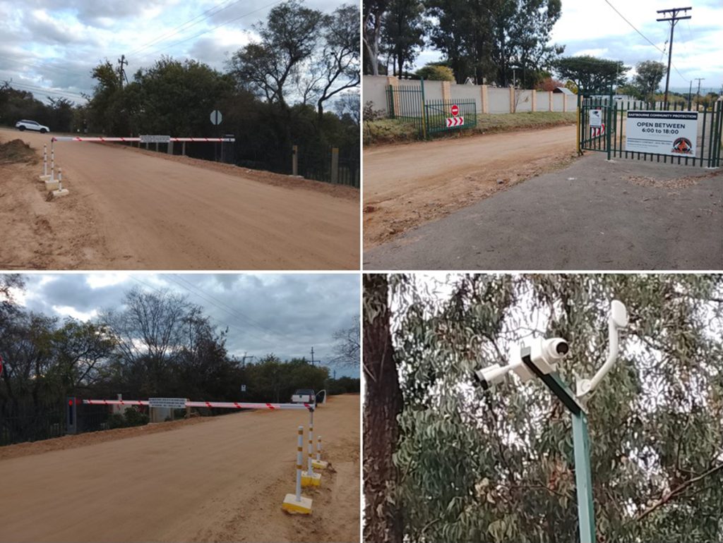
Rob Cunningham drove the Eastbourne camera project which was undertaken at the same time as the gates and booms. 5 cameras were installed in total. A single LPR (Licence Plate Recognition) camera was installed at the intersection of Eastbourne and Norfolk roads. Two cameras were installed at each end of Eastbourne facing up and down the street. Poles, electricity and wifi were provided by residents.
All cameras are connected to an off site monitoring company which is linked to the SAPS data-base. The cost of monitoring is R400 pm per camera and this is currently covered by the R7,000 contributed by each property towards the project (some residents who were unable to contribute this amount ‘paid’ through providing labour and materials). All residents (and Savika) are on a Whats App group which allows access to the camera feeds and Savika responds to any alert about false number plates, stolen vehicles or stationery or suspicious vehicle behaviour. After 8 at night pedestrian activity is reported and reacted upon.
Residents have reported a marked reduction in traffic and speeding since the installation of the cameras (and booms) and it appears that there have been very few incidents of crime reported.
Below: Midrand Reporter September 20, 2024

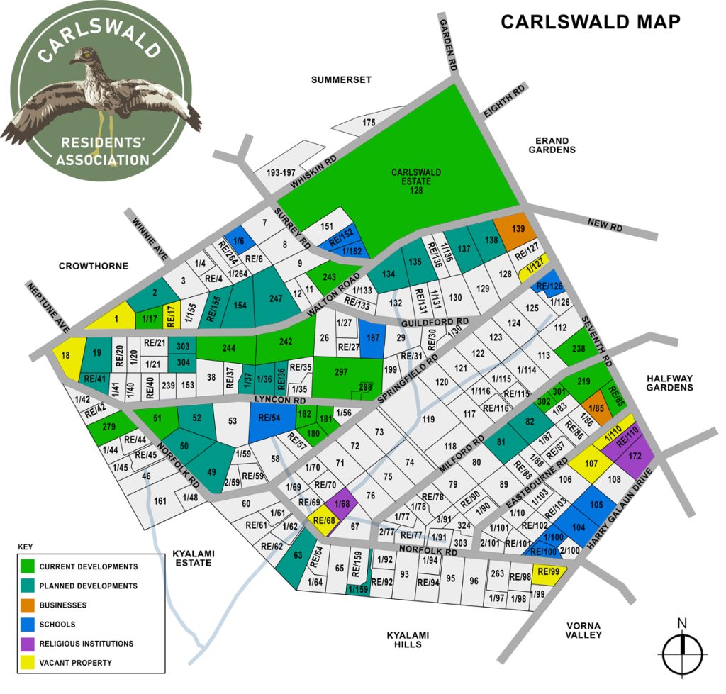
Development
With large properties in close proximity to schools, shopping centres, businesses as well as the N1 and the Gautrain Carlswald is being targeted by developers. As one developer stated in their application: “The area is under immense pressure for higher density residential development and the large low density agricultural holdings are no longer appropriate for this area.” The map below provides some indication of the extent of that pressure!
CRA’s VIEW ON DEVELOPMENT IN CARLSWALD
CRA aims to represent the concerns of the community in all proposed developments:
1. Height: As a community we agreed at the 2021 AGM that 2 storeys are the accepted norm for inner Carlswald.
2. Density: The Nodal Review 2020, the City’s planning document contains recommendations for density based on access to infrastructure and amenities while SPLUMA recommends 20-30. This discrepancy has caused many disagreements at Tribunals, but ultimately the COJ developed their Nodal Review in conjunction with CRA and are now ignoring the commitments made years ago.
3. Infrastructure:
Water – there is a significant water crisis in the City. All applications should be paused until this is resolved.
Electricity – the infrastructure in Carlswald AH is old and we experience a more than acceptable level of unplanned outages due to failing equipment.
Roads – the promised road upgrades to Harry Galaun/Norfolk & Harry Galaun/7th & Harry Galaun/Le Roux have not happened. All applications should be paused until this is resolved.
4. Schools: Only 1 public primary school and 1 public high school in Van Heerden Road at over full capacity. Private schools are not affordable to envisioned new residents and many operate without necessary approvals.
UPDATE ON DEVELOPMENTS
NEW APPLICATIONS
CARLSWALD ESTATE EXTENSION 78 – SITUATED AT 82 MILFORD RD CARLSWALD AH
The proposed township, which will be known as Carlswald Estate Extension 78 comprises of two erven, to be zoned “Residential 3”, 3-storeys,with a density of 43 dwelling units per hectare, allowing 96 units, including a gate house, club house, open space and uses ancillary thereto. The City of Johannesburg recommends 20-30 d/u per hectare for this stand. CRA has actively (and successfully) limited developments in inner Carlswald to 25 units per hectare and double storey. The developer is CRAFT Homes, a division of ABCON and is new to Carlswald.
CARLSWALD ESTATE EXTENSION 65 – SITUATED ON HOLDING 127/1 SPRINGFIELD RD CARLSWALD AGRICULTURAL HOLDINGS
A preliminary application has been circulated by the town planner requesting comments before the application is lodged. The application is for offices, clinic and coffee shop and for 22 two-storey units (sectional title apartments).
ON APPEAL
CARLSWALD ESTATE EXTENSION 61 – SITUATED ON REMAINDER OF HOLDING 36 CARLSWALD AGRICULTURAL HOLDINGS
We are still awaiting the outcome of our appeal to the ruling for 3-storeys and 64 dwelling units per hectare lodged in May 2024. This is around 3 times what the city’s own zoning permits.
CRAs main objective is to retain a maximum of 2-storeys for inner Carlswald and keep the densities within the limits recommended by the City of Johannesburg’s own planning and land-use documents (The Nodal review and SDF (Spatial Development Framework). These recommend 15-20 units per hectare for this site.
UNDER CONSTRUCTION
CARLSWALD ESTATE EXTENSION 48 – SITUATED ON REMAINDER OF HOLDING 83 CARLSWALD AGRICULTURAL HOLDINGS
This was approved for: 3-Storeys, 60% coverage, 1,5 FAR and 44 dwelling units per hectare (37 market and 18 inclusionary housing units) on 31 August 2021.
Leogem have completed are currently construction of 28 single storey units on it.
By far the best outcome Carlswald could hope for.
CARLSWALD ESTATE EXTENSION 44 – SITUATED ON HOLDING 51 CARLSWALD AGRICULTURAL HOLDINGS
This is the triangular property at the corner of Lyncon and Norfolk Rd. It was acquired by Cygnus Properties who have fenced the property, cleared all trees and vegetation and levelled the ground. 51 Norfolk Rd Ext 44 was approved at a max of 47 units for the site. The developer has assured neighbours that only 2-storeys will be constructed (approval allowed for 3 which was strongly opposed by residents).
APPROVED PENDING WATER AVAILABILITY
CARLSWALD ESTATE EXTENSION 44 – SITUATED ON HOLDING 51 NORFOLK RD CARLSWALD AGRICULTURAL HOLDINGS
Approved with a maximum of 47 units and 2-storeys.
CARLSWALD ESTATE EXTENSION 68 – SITUATED ON HOLDING 52 LYNCON RD CARLSWALD AGRICULTURAL HOLDINGS
Approved 20 dwelling units per hectare with a maximum of 48 dwelling units on site, of which 32 units shall be market and 16 units shall be inclusionary housing units.
PENDING APPROVAL
CARLSWALD ESTATE EXTENSION 36 – SITUATED ON HOLDING 19 WALTON AND 41 NORFOLK RD CARLSWALD AGRICULTURAL HOLDINGS
The application covering these two properties which span Walton and Norfolk Rd was approved in April 2019 at 20 units per hectare. The same owner recently acquired the triangular property Holding 20 Walton Rd. The buildings on Holding 41 Norfolk and 20 Walton Rd were demolished and vegetation cleared early in September with neighbours badly affected by noise (chainsaws from the early hours over the weekend of 6-7 September). Neighbours report the owners intend to restore the large house on 19 Walton Rd and to apply to build a hotel on the 41 Norfolk Rd property. They currently have no plans for 20 Walton (despite demolishing the house)… probably without any demolition orders!
OUTSTANDING APPLICATIONS
CARLSWALD ESTATE EXTENSION 56 – SITUATED ON HOLDING 137-138 WALTON RD CARLSWALD AGRICULTURAL HOLDINGS
An application to construct 3-storey development comprising of 223 dwelling units (50 units per hectare) (next to Indigo Nursery).
CARLSWALD ESTATE EXTENSION 52 – SITUATED ON HOLDING 154 WALTON RD CARLSWALD AGRICULTURAL HOLDINGS
The application is for 200 dwelling units (or 70 units per hectare) on a 2,85 hectare site.
CARLSWALD ESTATE EXTENSION 32 – SITUATED ON HOLDING 111 AND 113 MILFORD CARLSWALD AGRICULTURAL HOLDINGS
Galencia Properties, Villa la Seule: their approval for 111 Milford Rd was for 3 storeys and 30 dwelling units per hectare – a maximum of 68 dwellings. The application is for extending the approval to 113 Milford Rd for three storeys and 40 dwelling units per hectare or 86 dwellings on 113 Milford Rd and at the same time upping 111 to 40 per hectare.
Spatial Development Framework (SDF)
The SDF is an important component of integrated development planning for the City of Johannesburg. Carlswald Residents’ Association has submitted comment to several rounds of the SDF. Here is a link to the submission for 2022.